
Delta Dawn

If it keeps on raining, the levee’s going to break … Led Zeppelin, 1971
My wife and I own a camp on the bank of an old meander of the Mississippi River. The meander was the active channel of the great river until the mid-1800s, when riverboat captains grew tired of the twelve-mile detour and convinced the state to connect the two ends of the meander and shorten their journeys up and down the Mississippi. The river quickly switched to the steeper, straighter course and abandoned the meander, though a hydraulic connection remains when the surface elevation of the river water reaches seventeen feet above sea level at the gauge in Baton Rouge. In the first half of 2019, the Mississippi remained in flood stage for six months, and high water covered the cement slab beneath our camp. When the flood subsided, our slab was covered with eight inches of heavy, wet mud. The clean-up process was long and arduous.
The mother of all floods of the lower Mississippi occurred in 1927. The flood killed a thousand people, devastated communities, and fundamentally altered the trajectories of 20th-century politics, infrastructure, and geography1. In its aftermath, the Corps of Engineers dedicated itself to taming the Mississippi, and walled it in with tall levees all the way to the Gulf. All the millions of tons of sediment, collected from half a continent, that was once periodically distributed across the deltaic, estuarine environment of South Louisiana, would now be trapped in the riverbed or carried directly to deep water.
When sediment is deposited in deltaic and fluvial environments, the sedimentary grains are surrounded by water. Larger grains, think of coarse beach sand, immediately sink to the bottom of the water column and rest against each other. If you were to drain the water out of the sandy sediment, it would hardly compact because the grains of sand are supported by each other. The smallest of sedimentary particles are the microscopic, clay-sized particles that form mudstones and shales. Because they are so tiny, the water in the mud holds the particles at a distance. Over time, as additional sediment is loaded on top, the water in the mud is squeezed out and the material changes from something like a thick, squishy sponge to a hard, competent rock. This natural compaction of saturated mineral and organic sediment is responsible for much of the land loss in south Louisiana’s coastal marshes.
In New Orleans, as you walk through the history and debauchery of the French Quarter, or beneath the limbs of spreading live oaks in leafy, upscale Uptown, it’s hard to imagine how close you are to the edge of the world. From the tops of tall buildings downtown, if you look south, the horizon is blurred by a bleached sky and humidity that rises from grass, peat, and brackish water. The “shaky prairie,” so called because the ground underfoot was so soft, peaty, and waterlogged that it trembled like a bowl of Jell-O when you stepped on it, is just beyond the west bank communities of Marrero, Estelle, and Woodmere. It’s here, no more than twenty miles from downtown New Orleans, that coastal land loss begins in earnest. On the east bank of the river, in the upper reaches of Breton Sound, the edge of the world is even closer. From a fishing boat or a duck blind, the New Orleans skyline sketches ramparts above the horizon.
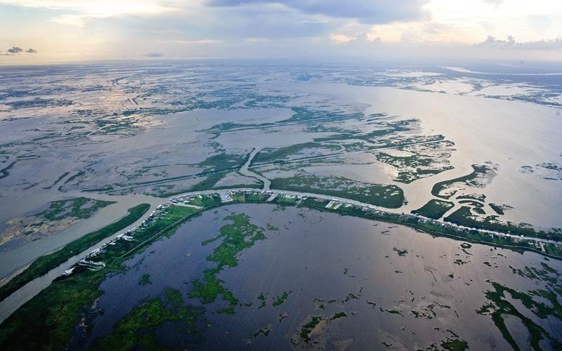
An LSU researcher named Sherwood “Woody” Gagliano was the first to measure coastal land loss in the late 1960s and early 1970s. His early conclusions, that the state was losing 16.5 square miles of land every year, were considered outrageous by some state and Corps of Engineers officials. They couldn’t believe it. In the late 1970s, new studies utilizing satellite imagery and computer analysis confirmed and amplified the findings. Land loss had jumped to nearly 40 square miles per year by 1980.
The basics of deltaic sedimentation were well understood in the 1970s, and researchers like Gagliano recognized that diverting portions of the river into areas like Breton Sound and Barataria Bay was a possible solution to land loss. A late 80s report by the Coalition to Restore Coastal Louisiana, titled Coastal Louisiana: Here Today, Gone Tomorrow? embraced the idea of a large river diversion to combat land loss and restore a vibrant marsh ecosystem. In 1990, Louisiana Senators John Breaux and J. Bennett Johnston advanced federal legislation to fight coastal land loss issues. The legislation provided funding—$40 million per year—and established a federal/state task force to identify and implement projects to protect Louisiana’s vital wetlands, which buffer storms and nurture a coastal ecology threatened by subsidence and erosion. Finally, in 1998, a diverse group of stakeholders published a book-length document called Coast 2050: Toward a Sustainable Coastal Louisiana. This detailed plan identified dozens of policy recommendations for all of South Louisiana, from Lake Ponchartrain to Holly Beach west of the Calcasieu River. The problem was the cost, which was estimated at $14 billion. Frustrated proponents of major projects like river diversions wondered what it would take to get state and federal governments to commit the necessary resources. Some speculated that only a major disaster would be sufficient. Between 2005 and 2010, there were three of them.
Hurricanes Rita and Katrina, just three weeks apart in 2005, highlighted the dangers facing coastal communities, including the major American city of New Orleans. Their impacts were not unlike those of the Great Flood of 1927. Hundreds of thousands of homes were damaged, and more than a million people were displaced. Fuel prices skyrocketed, and grain shipments to global markets were delayed. And in 2010, the tragic blowout of BP’s Macondo well in the Mississippi Canyon area of the Gulf put Louisiana’s unique coastal ecosystem on nightly television all over the world. Although we name hurricanes as if they were vengeful Gods and Goddesses, we cannot punish them for their cruelty and destruction. Not so with oil spills. Oil spills are owned, and the owners must pay for the damages they cause. Macondo finally supplied what hurricanes, reports, and lobbying could not: the money.
With billions of BP dollars set aside, the Louisiana Coastal Protection and Restoration Authority (CPRA) submitted a permit application for the mid-Barataria sediment diversion project to the U.S. Army Corps of Engineers (USACE) in June of 2016. A similar application for a mid-Breton Sound diversion project was submitted in March of 2019. Depending on the flow rate in the Mississippi, both projects were designed to deliver as much as 75,000 cubic feet per second (cfs) of river water and associated suspended sediment to Barataria Bay and Breton Sound, respectively. Although the Coast 2050 plan lists a wide spectrum of projects designed to restore and protect the Louisiana coast, from the maintenance and repair of barrier islands to the control of fur-bearing species like muskrat and nutria, river diversions are viewed as the heavy hitters, especially in the southeast coastal parishes of Terrebonne, Lafourche, Plaquemines, Jefferson, and St. Bernard. Mid-Barataria was expected to build new marsh on the west side of the river in Plaquemines Parish, and mid-Breton would do the same thing on the east side of the river.
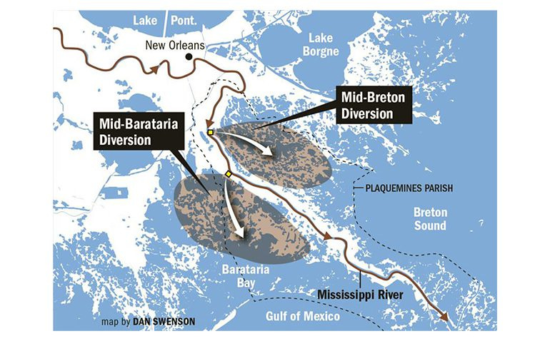
Mid-Barataria was approved during the John Bel Edwards administration, and approximately $600 million of the $3 billion price tag was spent before the project was cancelled by the Jeff Landry administration, which took over the reins of the state at the beginning of 2024. Mid-Breton has also been cancelled, though that project was still in the planning stages. Proponents of the projects were incensed, claiming that the Landry administration ignored science-backed solutions and favored the narrow self-interest of oyster fishermen and parish politics.
My personal experience with Mississippi River sedimentation, which occurs periodically on the cement slab underneath my camp, combined with my professional understanding of deltaic processes, predisposes me to believe in the marsh-building component of river diversions. Even with much of the historical sediment load of the Mississippi trapped behind locks and dams on the Missouri River and other tributaries, the water beneath my camp held enough sediment to drop a thick layer of mud in six months. But there are complications. The sediment is in the water column, but sediment diversion projects should probably be called freshwater diversion projects, since most of what is diverted is water, not sediment. The introduction of vast amounts of fresh water into Barataria Bay and Breton Sound would have dramatic, negative impacts on commercial fish species like brown shrimp and oysters, and on marine mammals like bottlenose dolphins that use the waters of Barataria Bay and Breton Sound as nurseries for their young. It was these ecological and financial impacts, along with permit issues and rising costs, that spurred opposition and the cancellation of mid-Barataria. Geological analysis of a major fault in the vicinity of the mid-Barataria diversion suggests an additional impediment to effective marsh restoration in that location.
My good friends at environMENTAL recently published a great piece on the inability of researchers to effectively model and predict the behavior of chaotic, coupled, nonlinear systems such as the Earth’s climate, or river diversions. They used two examples to illustrate the point. One was a trout habitat in the Absaroka-Beartooth Wilderness, just north of Yellowstone Park, and the other was the range expansion of Barred Owls that have made their way west into the habitat of smaller, less aggressive Spotted Owls. In both cases, efforts were underway to restore an ecosystem to an alternate or earlier state. The tactics being considered, and in one case, implemented, were harsh. All the fish in the watershed would be poisoned. Hundreds of thousands of barred owls would be shot. The questions arising from environmental groups and other interested parties were both moral and practical. Should fish that were stocked in a watershed a hundred years ago be killed just so that the watershed can be used as a protective nursery for native cutthroats that didn’t exist in the watershed in the first place? Should barred owls that have migrated across the country entirely of their own accord be killed because they out-compete the Spotted Owls? Will the plans even succeed?
In the case of land loss in South Louisiana, there is no doubt that the Sieur de Bienville’s choice of a bend in the Mississippi River for La Nouvelle-Orléans in 1718 altered everything about the fecund, marshy landscape that surrounded the new community. From the moment those early settlers chose to live on the margin of the great river, the efforts to contain it within its banks began. Early levees were small and of limited extent, but by the end of the 1800s, the value inherent in the cities, towns, and farms adjacent to the river had increased to the point that the price of robust flood protection, and any tradeoffs that protection might entail, were swept aside in a flurry of infrastructure improvement. The new levees kept the wheels of commerce turning, but the vast marshes that bracketed the river south of New Orleans, nourished for centuries by overbank floods, stopped growing and began to sink.
Additionally, the dredging of thousands of canals, small and large, for navigational purposes and access to oil and gas drilling locations has allowed saline Gulf waters to intrude into interior marsh, killing grass and trees and speeding erosion. I think there’s not much doubt humanity has accelerated the loss of coastal wetland in Louisiana, but by how much?
I can’t answer the question definitively, but consideration of the geomorphology of the current delta and 20th-century events allows for the construction of a plausible counterfactual.
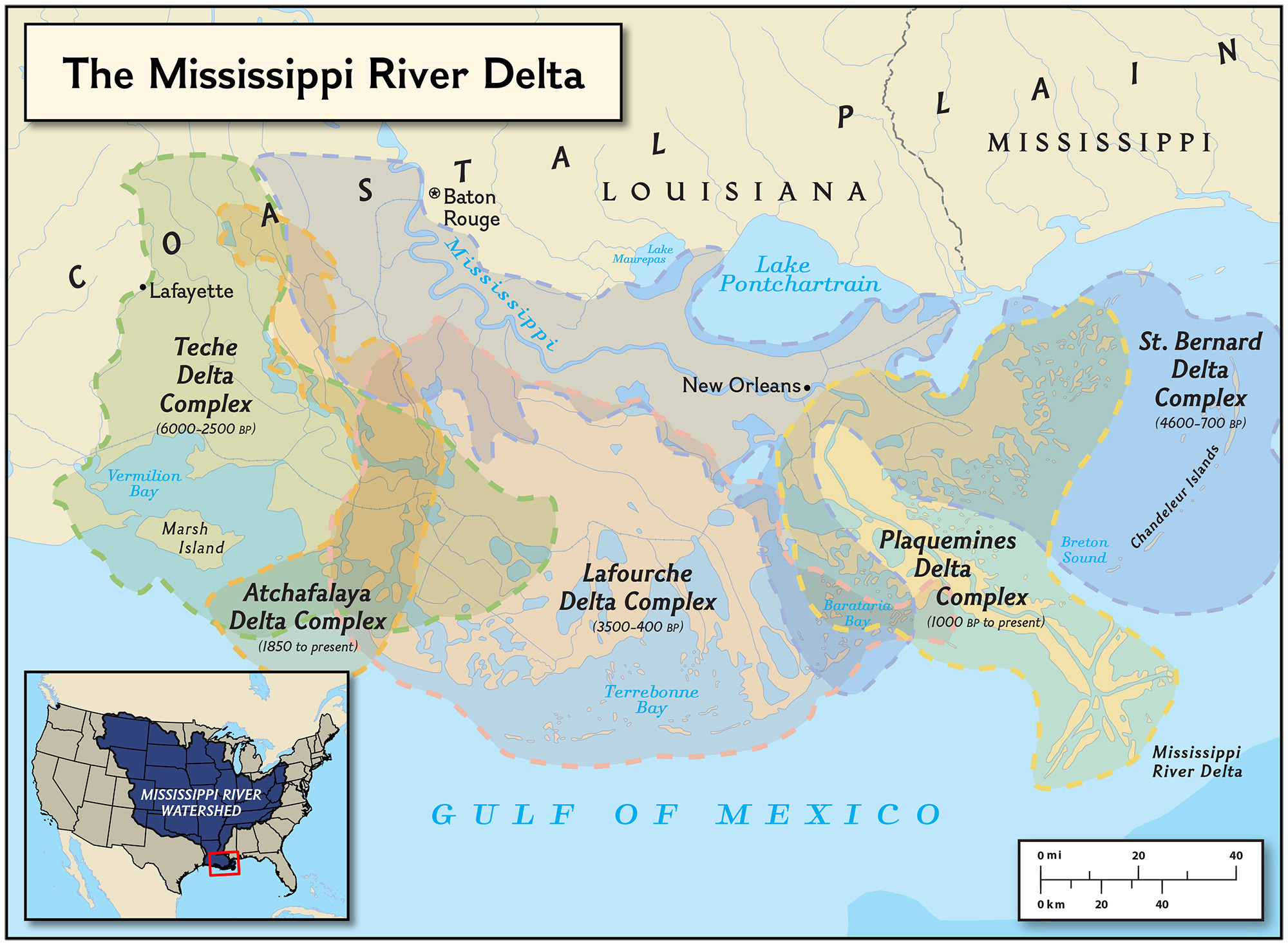
It is perhaps helpful to think of the last stretch of the Mississippi River—think everything below New Orleans—as a garden hose that is held firm by a gardener, until it isn’t. When the hose gets away from the holder, it whips around for a bit until the gardener chases it down and grabs it again, holding it firm in a different spot. The river behaves similarly. Once it chooses a path to the sea, its sediment load begins to build a delta—sand, mud, and marsh—outward into the Gulf. Over time, the growth of the delta flattens the path to the open sea, and the runoff of half a continent begins to seek a steeper, shorter passageway. When it finds that steeper path, the river abandons the old delta lobe and starts to build a new one. Deprived of the replenishing sediment of the river, the old delta lobe starts to sink into the sea.
It only takes a glance at Google Earth or Google Maps to see that the current Mississippi Delta has built itself nearly to the edge of the continental shelf. If you don’t know how to identify the continental shelf, look at a satellite image and note the sudden change from light blue water near the coastline to dark blue water as you move seaward. The current delta reaches much further into the Gulf than the coastline immediately east and west. This is evidence of a mature delta lobe that the river would prefer to abandon. If not for the efforts of man, it would have.
The Old River Control complex is about ten miles north of my camp in Pointe Coupee Parish. The locks, sills, dams, and gates that make up the complex are designed to divide the total flow of the Red and Mississippi Rivers above the complex in a 70/30 ratio. Seventy percent of the total flow goes down the Mississippi, and thirty percent is sent into the Atchafalaya River. Down the course of the Mississippi, it is over 300 miles from Old River to the Gulf. Down the Atchafalaya, it’s less than 150 miles, meaning the bed slope in the Atchafalaya is more than twice as steep, on average, as the bed slope of the Mississippi below the control structure. Can you guess why the control complex exists?
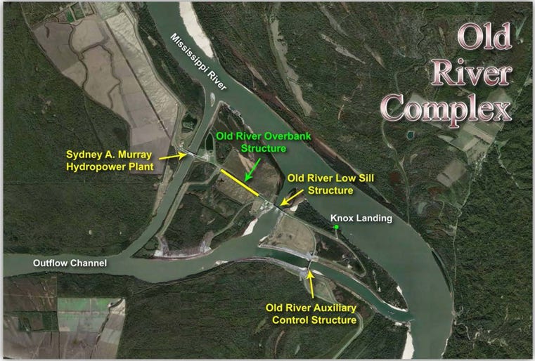
In 1951, engineers and scientists concluded that the Mississippi River would soon change its course and follow the much straighter, shorter path of the Atchafalaya River to the sea. Work on the Old River Control Structure began almost immediately to preserve the commercial interests served by the river as it is.
Changes in a river’s course tend to occur in the same way Hemingway’s character describes how he went bankrupt in The Sun Also Rises: gradually, then suddenly. The gradual part began not long after Columbus sailed across the Atlantic, when a meander loop of the Mississippi pushed far enough west to intersect the Red River, which ran a parallel course to the Gulf. The encroachment of the Mississippi created two rivers where before there was one. The Red became a tributary to the mother river, and the old southerly portion of the Red became the Atchafalaya River, a distributary of the Mississippi. In the 1800s, the gradual capture of the Mississippi by the Atchafalaya was halted for decades by a massive log jam that restricted the flow of water down the Atchafalaya. Captain Shreve, namesake of Shreveport, eventually cleared the jam, and the Atchafalaya resumed its slow expansion. For our thought experiment, let’s assume that in the absence of the control structure, the sudden part of the river changing direction occurred in 1973. Why 1973? That year saw the second-greatest flood, by volume, in the lower Mississippi River. Only the 1927 flood was larger. The massive flood stressed the control structure at Old River to the point that engineers feared its collapse, and the cataclysm of a full-scale switch to the Atchafalaya. So, with no human interference beyond the rudimentary controls installed in the 18th and 19th centuries, the river changes course in 1973, and all the marsh in Barataria Bay and Breton Sound begins to sink. We might have hurried it up by a hundred years or so, but the result is the same in the long run. If you doubt, look at the Chandeleur Islands, which are the last vestige of an old delta lobe that was active around 2,000 years ago. The islands remain above the waves because they consist of coarser, sandy sediment that does not dewater and compress like the muddy, silty sediment that once formed a marshy delta behind them. All the marsh is gone, sunk beneath the open waters of Breton Sound.
Folks who are passionate about coastal restoration, and river diversions in particular, will probably scoff at my fatalistic counterfactual. Their attitude might be summed up as 'do not go gentle into that good night.' If we, to this point, have hurried the process of coastal subsidence, should we not try to slow it down? The answer, as always, depends on the type of intervention and the resultant trade-offs. Large river diversions come with large trade-offs. Let’s look at some of them.
For a preview of the ecological impacts of a large-scale diversion, you need only to return to the year 2019, when the long-duration flood of the Mississippi deposited a thick layer of muck at our camp in Pointe Coupee Parish. The Bonnet Carré spillway is one of three major flood control projects built on the lower Mississippi River in the aftermath of the 1927 flood. Bonnet Carré sits just above New Orleans, and opening its gates allows river water to flow into the west end of Lake Ponchartrain, thus reducing the volume of water that flows through New Orleans and beyond. In 2019, the spillway was opened twice, for a total duration of four months. At the river’s peak flow, 206 bays in the spillway were open, conveying 206,000 cubic feet per second of river water into Lake Ponchartrain. This massive slug of fresh water wreaked havoc on the Lake Ponchartrain Basin and Mississippi Sound, and serves as a warning for what will happen in Barataria and Breton if major river diversions are ever completed.
The environmental organization healthygulf.org had this to say about the Bonnet Carré in 2019.
The river water carries a heavy pollutant load, causes salinity levels to crash, and is colder than the warm waters in the receiving lakes and sound, causing an array of impacts that adversely affect wildlife and destroy habitat. In 2019 alone, when the Spillway was opened twice for a total of four months, oyster beds were destroyed, hundreds of dolphins died and washed ashore, and the U.S. Department of Commerce declared a fisheries disaster as a result of the damage done to commercial fisheries.
The two main fisheries expected to be impacted by the mid-Barataria project are the oyster and shrimp industries. To compensate, the project's financing included $400 million for damage mitigation, which included tens of millions for relocating oyster beds and purchasing new refrigeration equipment for shrimp trawlers that may have to range farther from home to find their catch. There was also $60 million allocated for the dolphins, but the money is worthless if the dolphins are dead. It’s also worth noting that the dolphin impacts of the mid-Barataria diversion required a waiver to bypass requirements of the Marine Mammal Protection Act. When NOAA and some environmental NGOs expressed reservations about the project because of the impacts on dolphins, proponents of the project were able to attach the waiver to additional, unrelated legislation and pass the bill, metaphorically at least, under cover of darkness.
A discussion about trade-offs could be characterized as what am I getting, and what am I giving up? Sophisticated computer models were used to predict the amount of new land the mid-Barataria diversion would create. One modeling group used a program called Delft 3D developed at Delft University in the Netherlands. Other programs used included HEC-RAS (Hydrologic Engineering Center - River Analysis System) and AdH (Adaptive Hydraulics), both from the Army Corps of Engineers. Depending on who was doing the modeling and what programs were used, estimates of new land ranged from 7,000 to over 20,000 acres, nearly an order of magnitude difference. You might think that 7,000 acres is plenty of new land, but the discrepancy points to two things. One is the cost-benefit analysis. If you’re going to destroy existing fisheries and kill dolphins, even if it’s a temporary state of affairs, you’d better be getting a lot for your money. The other is uncertainty. Even if the models agreed, there’s no guarantee the real-world results would mimic the predictions. When the models disagree, you have to start wondering if you’re entering the realm of the old physics joke: assume spherical horse. Studies of two, smaller diversion projects at Davis Pond and Caernarvon, both operational for decades, have shown that the introduction of nutrient-rich freshwater may damage the coastal marsh as much or more than it helps. Both of these projects were designed, firstly, to address salinity issues, not build land, but lessons learned from them should be used to inform the modeling of larger projects.
In 2017, a group of professors, PhDs, and professional geoscientists participated in the public comment process of the Environmental Impact Statement (EIS) for the mid-Barataria diversion. Their comment began as follows:
The natural surface processes of the deltaic plain cannot be properly understood outside of the context of subsurface geology. The geological history of the Mississippi River Delta Plain, and older sediments that underlie it, record an inter-dependence between the river, its delta and geological features such as faults and salt structures.
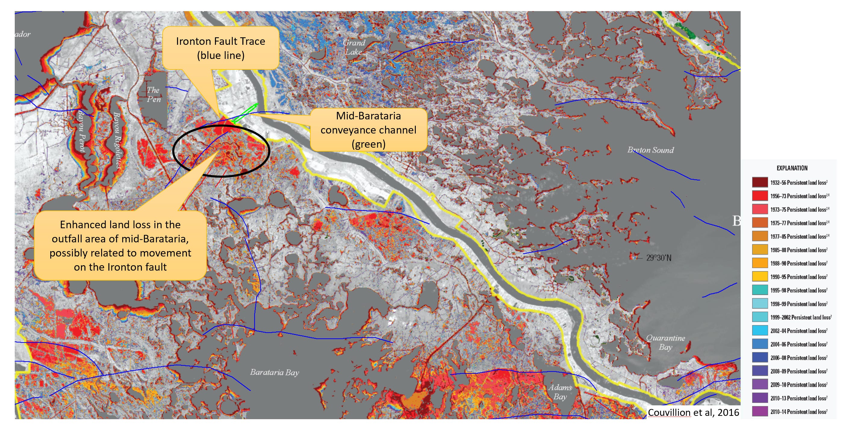
The purpose of their comment was to inform planners of a possible relationship between areas of enhanced land loss and active growth faults that extend upward to ground level. Maps showing the relationship between land loss and faults mapped using seismic data sourced from the oil and gas industry were included as part of the comment. The outfall area of the mid-Barataria project is situated on the hanging wall, or downthrown side of the Ironton fault, which has been accurately mapped using seismic and well-log data. The fault is thought to extend to the surface, and the hanging wall block is associated with an area of enhanced subsidence. The group recommended acquiring high-definition seismic and sediment core data to help assess the possibility that fault movement could negatively impact land building efforts at the chosen location. The response was terse.
“… there is insufficient information on which to evaluate the impact of faulting on the proposed Project or the impact of the proposed Project on the future fault movement.”
Given the tradeoffs, the steady resistance from fishermen and other interested parties in the outfall area, and the technical shortcomings, why did the project go forward? It seems that enough people in the right places just really wanted it to. From the days of Woody Gagliano’s initial work on land loss in the 1970s, a major river diversion has been viewed as a holy grail solution to the problem of coastal subsidence and land loss. Just let the river do what rivers do naturally. In Mike Tidwell’s book from the early 2000s, Bayou Farewell, his language takes on a reverent quality when he writes about the plans for a Third Delta Conveyance Channel that would deliver river water at flow rates up to 200,000 cfs to the upper reaches of Terrebonne and Barataria Bays. Practically, the project got a big boost in 2015 when former Louisiana Senator Mary Landrieu became a “strategic advisor” to the Walton Family Foundation. Following the announcement of her relationship with the Waltons, the Foundation committed millions of dollars to environmental NGOs that undertook lobbying and PR efforts to advance the project in the face of obstacles like the Marine Mammal Protection Act. Following the playbook used by climate activists, Governor John Bel Edwards declared a state of emergency in 2017:
“… the Louisiana coast is in a state of crisis and emergency that requires immediate and urgent action and attention to avert further injury to the lives, property, health, safety, and welfare of the citizens of Louisiana and the nation …”
“… it is requested that the Congress consider legislation to provide for means by which to expedite all federal permitting and environmental review, including creation of waivers, categorical exemptions, alternative measures, or expedited processes.”
Proponents of the mid-Barataria and mid-Breton projects are convinced that the long-term benefits will outweigh the short-term costs. It’s easy to say when it’s not your livelihood at stake. The people who will be most affected by major river diversions in Plaquemines or St. Bernard parishes are the descendants of trappers, fishermen, farmers, and small business owners who lost everything during the 1927 flood when a group of New Orleans power brokers, most of them bankers and members of elite clubs and Krewes, convinced the state and federal governments that it was necessary to blow a hole in the eastern levee at Caernarvon, just downstream of the city. In the aftermath of the mud and fresh water that swept away their homes and livelihoods, the insults continued to accumulate. First, it became known that the levee breach at Caernarvon was not needed to protect the city. Then, the bankers who pledged full compensation to the damaged parties, and who stated “the relief to be afforded is a moral obligation undertaken by each and every person … as evidenced by their signed obligation to that effect,” balked at the $35 million in claims, and paid ten cents on the dollar. More than 1,000 claimants received nothing. Is it any wonder that current residents are skeptical of plans to divert the river in their direction? Compensation to follow, of course.
Despite a century of land loss, the Barataria Basin remains a productive fishery, and coastal communities like Grand Isle have proven resilient in the face of recent, dangerous storms such as Hurricane Ida in 2021. In Bayou Farewell, author Tidwell predicts a decline in the commercial shrimp catch after big years around the year 2000. The shrimp catch has fallen, but the biggest obstacle for the shrimp industry is the influx of farm-raised shrimp from foreign countries, which has depressed prices and made it difficult for Louisiana shrimpers to earn a living.
Mid-Barataria and mid-Breton are cancelled, but the state is not abandoning its efforts to sustain Louisiana’s estuarine coastline. The CPRA is developing a new “2029 Coastal Master Plan” to “reduce storm surge-based flood risk to communities, provide habitat for commercial and recreational activities, and reinforce infrastructure critical to our working coast.” A public solicitation process for new projects closed in October, 2025. A second solicitation process will occur in the summer of 2026. Many types of projects are being considered, from barrier island maintenance to forested wetland restoration. In the vast, grassy marshes and bays in between, ridge restoration, sediment dredging, and river diversions (probably smaller than mid-Barataria) will all be parts of the toolkit. The coast needs to be maintained for protection from hurricanes, for the commercial fisheries, for the plants, fish, birds, and mammals that make the Louisiana coast an explosion of life and natural beauty, and for the ways of life, new and old, that humanity has adapted to a unique, coastal ecosystem. How long it can be sustained in the face of natural processes — such as subsidence, fault movement, and rivers changing course — that work against it is a different question. Some of the very last lines of John Barry’s epic work on the 1927 flood, Rising Tide, The Great Mississippi Flood of 1927 and How It Changed America, are as follows:
Many engineers believe that sooner or later, no matter what man does, the Mississippi will shift its channel to the Atchafalaya. And a finger of the sea will climb north past New Orleans, north to Baton Rouge.
The best generals know there comes a time when it makes more sense to fall back to a more hardened position than continue to defend, at increasing cost, indefensible outposts. We’re not there yet, and I believe there are strategies to keep the Louisiana coastline productive and protective for a century (centuries?) to come. After that, who knows?
Like (🖤) this post and find your way to higher ground.
Before you go:
Please click the 🖤 button, comment, share, and subscribe!
The book Rising Tide by John Barry is an epic story of the 1927 Mississippi River flood, detailing the scientific, political, financial, and geographical impacts it had on the United States. Highly recommended.
Great post, Trevor.
What's going on with geophysical fluid dynamics, geology, sediment flow, etc. and the freshwater diversion projects along the LA coast is another great example of "don't just stand there, do something!" good intentions.
The system is chaotic and nonlinear, the forces at work nearly impossible to model with high resolution, and the consequences of the "solutions" extend far beyond their cost to build and operate.
The scale, the geophysical fluid dynamics and geology, water quality and upstream sediment loads involved, and other economic considerations make this situation far more difficult to model accurately and implement with minimal consequences than our examples you referenced.
Great job helping those unfamiliar with that incredible ecosystem understand the issues at play.
👏👍👍
Two early 70's song classics to start this post? I'm in!
https://youtu.be/YBXOOSEPGSU?si=72ERuBe7LTWCurmd